Blogs

Navigating Peak Hurricane Season

Lessons from Katrina & 2025 2H Outlook

Katrina – A Look Back 

This week marks the 20th anniversary of Hurricane Katrina – one of the benchmark “black swan” events this century. Katrina made landfall in Louisiana on August 29, 2005. The devastating storm reached Category 5 status in the Gulf of Mexico prior to landfall as maximum sustained winds peaked at 175 mph (281 kmph). 

In the end, 1,836 people died which is the second highest in recorded history in the Atlantic Basin; the 1900 Galveston, Texas storm was highest at nearly 10,000 fatalities. Economic loss from Katrina was 167 billion USD, the costliest hurricane in history, adjusted for inflation adjusted. 

Graphic showing the impact of hurricane Katrina

Figure 1: Hurricane Katrina caused significant loss of life, changed the demographics of New Orleans, and exposed vulnerabilities in supply chains 

Impact of Hurricane Katrina

Looking back, Katrina exposed how vulnerable national and global supply chains were. Impacts via Katrina went on for months and even years.  

New Orleans has never fully recovered from a demographic standpoint. Virtually all transportation in the south-central U.S. was halted – port, road, rail, and air. The areas that were most impacted near the center of landfall suffered severe damage. The damage was long-term in duration lasting months and in some cases, years.  

The energy and agricultural sectors were impacted for years while damage to manufacturing, and distribution facilities was severe. Retail and consumer good disruptions reverberated around the globe for years. 

Katrina forced the supply chain industry to think about and develop long term changes in supply chain risk management, including more robust contingency planning. These practices, which arguably started after the 2005 hurricane season, are still being developed and refined today. The event also showed the importance of logistics agility, infrastructure resilience and public-private partnerships. An example of this is the Everstream/ALAN (American Logistics Aid Network) partnership. 

Situation Brief: Navigating Peak Hurricane Season – Lessons from Katrina & 2025 2H Outlook

Watch on-demand

The 2025 Hurricane Season: 1st Half 

We are now entering the height of the Atlantic hurricane season, the period of greatest risk for tropical disruptions to global supply chains. Statistically, the season’s midpoint falls around September 10, a reminder that the most active weeks are still ahead. 

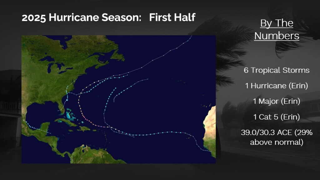
Through the first half of the 2025 season, the Atlantic Basin has generated six tropical storms and one hurricane. That lone hurricane, Erin, never made landfall but did undergo rapid intensification, reaching Category 5 strength. Thanks to Erin’s intensity and longevity, the season’s accumulated cyclone energy (ACE) has already reached 39.0, running about 29% above the long-term average of 30.3 (ACE data is as of August 28.

The first half of the 2025 hurricane season has produced only one hurricane, which did not make landfall

Figure 2: The first half of this year’s Atlantic hurricane season has not caused much supply chain disruption 

Our May Forecast 

In early May, we released our initial hurricane season outlook. The key takeaways were: 

  • Atlantic at highest risk: Among all Northern Hemisphere basins, the Atlantic carried the greatest risk relative to climatology. 
  • ACE forecast near normal: Our seasonal ACE projection was 130–150, broadly consistent with historical averages. 
  • Elevated U.S. coastline threat: The risk of tropical impacts along the U.S. coastline was assessed to be slightly above climatology. 
  • No repeat of 2024: While elevated, 2025 was not expected to reach the extremes of last season. 
  • Items to watch: Saharan dust outbreaks, the North African Intertropical Convergence Zone (ITCZ), and the timing of La Niña’s return. 

Our research and analysis focused on the evolving sea-surface temperature (SST) profile: borderline neutral to La Niña conditions in the equatorial Pacific, and slightly above-normal SSTs in the Atlantic Main Development Region, both key indicators for seasonal risk. 

So far, the season has gone as planned with no major surprises. One minor surprise was that Major Hurricane Erin did not cause any direct impacts or issues as it stayed out to sea. Another minor surprise has been a slightly faster return of La Niña conditions in the equatorial Pacific. Overall, the outlook has verified well, with no major deviations from our preseason expectations. 

The 2025 Hurricane Season: 2nd Half (The Forecast) 

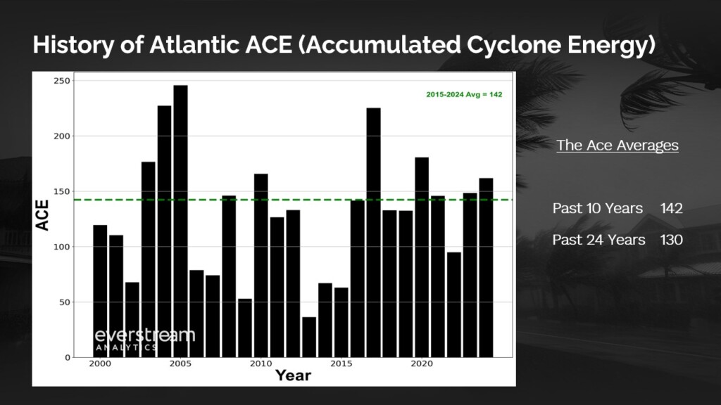
Looking forward to the remainder of the season, our forecast from May, for near normal activity, is unchanged. In other words, our Atlantic ACE forecast range remains 130-150.  

In the details, we expect the next active window in the Atlantic basin to occur during the second half of September and early October. This forecast window aligns with climatologically some of the most active times of the year within the basin, suggesting the bulk of this season’s storms could occur during this relatively short window. 

Graph showing the Accumulated Cyclone Energy from 2000 to 2024

Figure 3: Everstream Analytics predicts this year’s Atlantic ACE will fall between 130-150 

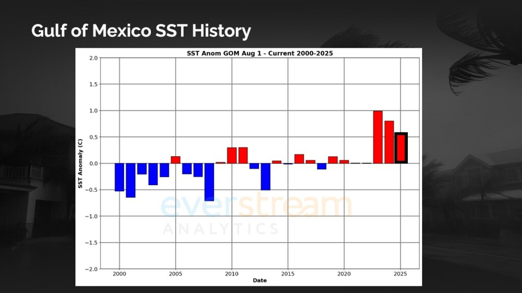
Some items to keep a close eye on are rapidly developing storms in the Gulf of Mexico as SSTs are exceptionally warm. These very warm waters act as fuel for developing storms of which there is plenty available to support strong hurricanes.  

A graph showing that the sea-surface temperature in the Gulf of Mexico is very high in 2025

Figure 4: This season, high sea-surface temperature (SST) in the Gulf of Mexico could cause rapidly developing storms.  

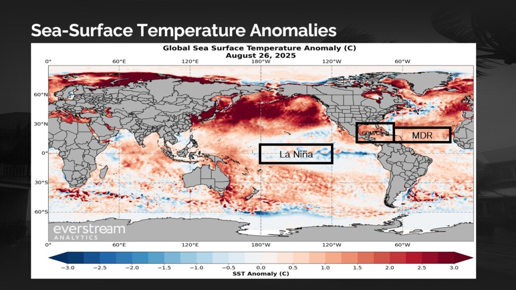
Another item to monitor would be a potential later end to the season. SSTs in the central Atlantic and the Gulf of Mexico are both markedly above normal, combined with a quicker move toward La Niña conditions in the fall could both favor tropical development at the late stages of the season. 

This late season risk would be favored in the Caribbean and along the East Coast of the US. All in all, it is too early to write this season off as the most active period of the season is yet to come. 

A graphic show high sea-surface temperatures in the Atlantic and the Gulf of Mexico

Figure 5: Sea-surface temperatures in the central Atlantic are higher than usual, which combined with a quicker move toward cooler La Niña conditions could cause tropical storms later this hurricane season. 

Situation Brief: Navigating Peak Hurricane Season – Lessons from Katrina & 2025 2H Outlook

Watch on-demand

Share this post